Lakes Near Monroe, LA: Where the Water Is
- The nearest water is not all the same kind of place
- Quick guide to lakes and water near Monroe
- Black Bayou Lake is the close nature choice
- Cheniere Lake is the local lake-and-park choice
- Lake D’Arbonne is the full state-park day
- Caney Creek Reservoir is the larger reservoir outing
- Bayou DeSiard is city water, not a lake substitute
- The Ouachita River is for a riverfront hour or a planned launch
- Which water fits the afternoon you have?
- Fishing requires an access and license check
- Paddle and boat with the rules in front of you
- Check seven things before leaving Monroe
- Sources
The nearest water is not all the same kind of place
For a lake near Monroe, start with Black Bayou Lake for a close wildlife walk or paddle, Cheniere Lake for a local lake-and-park outing, Lake D’Arbonne for a fuller state-park day, or Caney Creek Reservoir for a larger boating and overnight trip. Bayou DeSiard and the Ouachita River are useful city-water alternatives, but neither is a lake.
Choose by what you want to do, not by which blue shape looks largest on a map. A fishing pier, shaded bank, paddle launch, swimming area, and wildlife boardwalk are five different afternoons.
Quick guide to lakes and water near Monroe
| Water | What it is | Best first use | Planning reality |
|---|---|---|---|
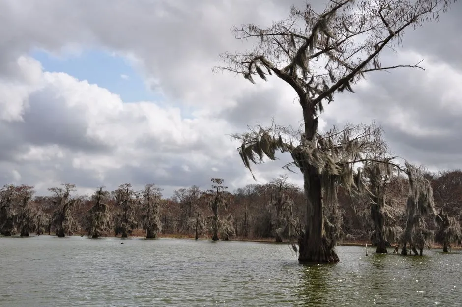
| Black Bayou Lake | A cypress-studded lake within the National Wildlife Refuge | Wildlife viewing, boardwalks, fishing, or a non-motorized paddle | Refuge rules, building hours, weather, and water access need a same-day check |
| Cheniere Lake | A lake west of Monroe | Picnicking, fishing, or camping; paddle only after a current condition check | A temporary drawdown is currently limiting paddling, and exact access still needs verification |
| Lake D’Arbonne | A large lake beside a state park in Farmerville | Fishing piers, boating, paddling, trails, camping, or cabins | It is a destination day, not a quick downtown water stop |
| Caney Creek Reservoir | A 5,000-acre reservoir in Jackson Parish | Boating, fishing, a designated beach when open, or an overnight park stay | Check the chosen access point and current Jimmie Davis State Park operations |
| Bayou DeSiard | An impounded historic channel running through Monroe | An urban paddle or waterside pause | Public access varies by section; use a named, current launch |
| Ouachita River | A working river through Monroe and West Monroe | River views, a levee walk, or a launch from a confirmed public access | Current stage, current, weather, and launch conditions matter |
The most useful distinction is scale. Black Bayou and Bayou DeSiard can fit around other Monroe plans. Lake D’Arbonne and Caney Creek reward an outing designed around the water.
Black Bayou Lake is the close nature choice
Black Bayou Lake National Wildlife Refuge is the simplest answer when someone wants a real lake and a nature visit without building the whole day around a long regional drive. The U.S. Fish and Wildlife Service lists fishing, accessible trails, non-motorized boating, birding, biking, photography, and running among its activities.
The refuge is more than a view from the parking area. The official Black Bayou Lake visit page identifies a wildlife pier, Nature Trail Boardwalk, and a range of routes from accessible paths near the visitor center to more primitive trails elsewhere. That mix makes it the strongest first choice for a group whose members do not all want the same level of exertion.
Treat the visitor center and the outdoor refuge as separate checks. Building hours can vary with volunteer availability, while access rules govern the wider property. The refuge currently prohibits camping and drones, requires dogs to be leashed, and limits motors on the lake to 50 horsepower or less. Recheck those rules directly before leaving because refuge conditions and operations can change.
Our Black Bayou Lake first-visit guide covers the arrival sequence, the boardwalk-and-pier option, and what to verify before a paddle. It is the useful choice for a quiet hour, a short walk, or a first look at North Louisiana wetland habitat. It is not a promise of a particular wildlife sighting.
Cheniere Lake is the local lake-and-park choice
Cheniere Lake sits on the West Monroe side of the local map and offers a different outing: less refuge interpretation, more conventional park, fishing, camping, and lake access. Discover Monroe-West Monroe’s current Cheniere Lake Park listing places the park at 104 Cheniere Lake Road and describes a 3,000-acre lake, RV and tent sites, bath facilities, and laundry.
The current Cheniere Lake paddling guide says the lake is under a temporary drawdown recommended by the Louisiana Department of Wildlife and Fisheries and that paddling opportunities are limited. It rates all three mapped paddle routes intermediate. One mapped route begins at Cheniere Lake Park Lodge Boat Ramp, but that does not make every ramp, camping area, or lake edge interchangeable. Use the precise park area in navigation, then confirm current launch access, fees, facility status, and posted restrictions with the park operator.
Cheniere works well when the afternoon is about being beside a local lake rather than following an interpretive trail. Fishing access still requires a current check, and paddling should wait unless the current guidance, launch status, water level, and your skill all support it. Private shoreline is not public permission, and an old map pin is not a current launch notice.
For a no-boat visit, confirm that the park facilities you want are open before you go. For a boat visit, check the ramp, water level, local notices, and weather. Follow buoys and closure signs; do not enter a marked spillway or restricted area.
Lake D’Arbonne is the full state-park day
Lake D’Arbonne State Park in Farmerville is the clearest choice when the lake should carry most of the day. The Louisiana State Parks page describes a 655-acre park on a 15,250-acre lake, with five fishing piers, boat docks, a launch, trails, paddling, camping, cabins, and wildlife viewing.
That list explains the trade-off. Lake D’Arbonne offers more ways to build a complete outing than a city-edge stop, but it deserves more planning. A family might combine a short trail and pier time; an angler may care most about the launch and fishing access; an overnight visitor may use a cabin or campsite. Those are separate reservations and facility checks.
The park page currently lists four named trails: the one-mile Orange Trail, half-mile Green Trail, half-mile Blue Trail, and four-mile White Trail. Do not assume every person in the group wants the same route or that surface conditions will match the mileage. Ask about current closures and choose for heat, mobility, daylight, and recent weather.
Lake D’Arbonne is also the better answer when someone asks for “a proper lake day” rather than a quick lake view. Verify gate times, admission, rental availability, pool schedule, and reservation terms on the official page on the day you plan. Published hours and prices are operational facts, not permanent scenery.
Caney Creek Reservoir is the larger reservoir outing
Caney Creek Reservoir is a man-made reservoir, not a natural lake, though “Caney Lake” is common shorthand. The Louisiana Department of Wildlife and Fisheries waterbody management plan gives a surface area of 5,000 acres and places the public-park access at Jimmie Davis State Park.
The same state plan identifies two state-park boat launches, a public fishing pier, picnic sites, camping, cabins, lodges, and a swimming beach. Those details make Caney a strong candidate for a group that wants several forms of recreation in one place. They do not guarantee that each facility is open on a particular date.
Plan this as a regional outing. Confirm the operating status of Jimmie Davis State Park, the selected launch, beach, reservations, and any waterbody notices before driving. Use a designated swimming area only when it is officially open. A boat ramp is not a swimming beach, and a quiet-looking shoreline is not an access invitation.
Bayou DeSiard is city water, not a lake substitute
Bayou DeSiard flows through Monroe, including beside the University of Louisiana at Monroe. It can answer “where can I get on the water near town?” even though it does not answer “which lake should I visit?”
The local Bayou DeSiard paddling guide maps two out-and-back routes. One begins at Connerly’s Boat Launch; the other begins at the public Highway 134 ramp and can be shortened by turning back before the full route. Use the current map and named launch rather than improvising access from a bridge, campus edge, or residential bank.
This is the close-to-town paddle option when conditions, skill, equipment, and access line up. It is not automatically safer because the water looks calm. Wind, heat, lightning, boat traffic, submerged objects, and changing conditions still require a conservative decision.
If you only want to see Bayou DeSiard, a lawful public vantage point is enough. Do not treat private lawns, docks, or parking lots as public access.
The Ouachita River is for a riverfront hour or a planned launch
The Ouachita is the water that organizes Monroe and West Monroe geographically. It suits a riverfront or levee walk when the goal is moving beside the water rather than entering it. It can also support boating and fishing from confirmed public access, but the planning questions are different from a lake.
A river has current, changing stage, working-water traffic, and access points that can open or close. Check a current official river level and weather forecast, then verify the ramp or park you intend to use. Never infer safe entry from a bare bank or a path visible from the road.
For a first visit, a public river view pairs naturally with the first-day Monroe itinerary. Keep the lake outing separate unless the day has enough time and daylight for both.
Which water fits the afternoon you have?
Use this short decision order:
- For a walk with a lake view: start with Black Bayou Lake and choose the accessible pier-and-boardwalk area or a longer refuge trail after checking conditions.
- For a local picnic, launch, or camping option: investigate Cheniere Lake Park and confirm the exact area.
- For multiple park activities or an overnight: compare Lake D’Arbonne State Park and Jimmie Davis State Park on Caney Creek Reservoir.
- For an in-town paddle: use a published Bayou DeSiard route and its named launch.
- For water beside a city walk: choose a lawful Ouachita riverfront or levee route rather than forcing a lake trip into a short gap.
- For fishing: choose by public access and current rules first, then by the species and method you intend to use.
A lake’s acreage does not tell you whether you can reach the water, rent equipment, walk a trail, launch a boat, or return before a gate closes. Access turns geography into an outing.
Fishing requires an access and license check
Start with the current Louisiana Department of Wildlife and Fisheries rules, not a forum post or an old photograph of a sign. LDWF’s recreational fishing license page says people age 18 or older need a Basic Fishing License to fish recreationally in Louisiana waters, subject to the listed license types and exceptions.
Then check the specific waterbody or refuge rules. Black Bayou Lake is federal refuge land as well as Louisiana water, so both layers can matter. Cheniere, Lake D’Arbonne, and Caney Creek have their own managing bodies and access arrangements.
Do not promise a catch. Water level, season, temperature, vegetation, skill, and fishing pressure all change an angler’s day. A good guide can identify legal access and the right authority; it cannot book a fish.
Paddle and boat with the rules in front of you
Louisiana’s current required boating equipment page requires a properly sized, serviceable U.S. Coast Guard-approved personal flotation device for each person aboard a canoe or kayak. State rules also require children age 16 and younger to wear an approved PFD while underway on a vessel less than 26 feet long.
Carry the required equipment and wear the life jacket. Check the forecast, wind, lightning risk, water level, launch, route, daylight, and return before leaving shore. Tell someone the route and expected return. Do not paddle alone beyond your skill or in conditions you cannot manage.
The National Weather Service’s outdoor recreation guidance says to head to shore for high-wind alerts and for thunder or lightning. It also advises extra water, sunscreen, loose clothing, and shade breaks in excessive heat. These are decision thresholds, not comforts to consider after launch.
Check seven things before leaving Monroe
Before committing to any lake or waterway, confirm:
- the exact public access point and parking arrangement;
- current opening, gate, and building hours;
- admission, launch, rental, or reservation requirements;
- water level, weather, wind, heat, and lightning risk;
- swimming, fishing, boating, motor, pet, and trail rules;
- life jackets and other required equipment;
- the last safe turnaround time for the group.
The nature-near-town section can help match the water to the pace of the day. The right choice may be a boardwalk ten minutes from the rest of the plan, not the largest lake in the region.
Sources
- U.S. Fish and Wildlife Service: Black Bayou Lake visit information
- Discover Monroe-West Monroe: Cheniere Lake Park
- Discover Monroe-West Monroe: current Cheniere Lake paddle conditions
- Louisiana State Parks: Lake D’Arbonne State Park
- Louisiana Department of Wildlife and Fisheries: Caney Creek Reservoir management plan
- Discover Monroe-West Monroe: Bayou DeSiard paddle routes
- Louisiana Department of Wildlife and Fisheries: fishing licenses
- Louisiana Department of Wildlife and Fisheries: required boating equipment
- National Weather Service: outdoor recreation safety